|
|
|
|
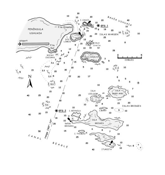
11.6 Paso Chico (Islas Bridges) Local Charts ARG H 477-H 478 * CHILE 13000-1301-1307 Other Charts UK 1373-3425 * US 22430-22433-22436 Remarks: Paso Chico is a shortcut that conveniently links Ushuaia to the westbound route avoiding the rounding of Islas Bridges and Islotes Eclaireurs. Entering Paso Chico from the N towards Canal Beagle, the track passes E of Islas Casco, Dos Lomos and Península de Ushuaia and W of Islas Chata, Conejo (Rabbit in Chilean charts) and Isla Bridges, the latter more to the S. The minimum depth is 5.5 metres. The route is easy to follow, but nonetheless, we give directions with GPS waypoints in case bad weather should reduce visibility, as often happens during sudden squalls. Vessels S-bound from Ushuaia, pass Isla Casco (once marked by a light structure, now lying broken on the ground) and should enter the pass at GPS1, S 54°50'14 - W 68°14'82, located 1.5 cables E of the island. Then the track leads SW passing E of Isla Dos Lomos, which is marked by a light structure. Once the latter island is abeam, steer a direct course towards GPS 2, S 54°51'87 - W 68°16'50, lying 4 cables NW of the Bridges light structure, standing on the W extremity of Isla Bridges. The track is the same as the one marked by the alignment formed by the Isla Casco light structure and the one of Isla Dos Lomos. The route W is now deep and clear of dangers, but watch out for the isolated broad patches of kelp, an unpleasant obstacle to meet full speed. The passage between Isla Casco and the Pta. Oriental of Península de Ushuaia is possible, having a minimum depth of 3 metres, paying attention to the kelp patches. |