|
|
|
|
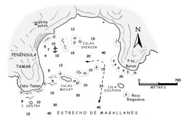
8.2 Puerto Tamar Location Estr. de Magallanes (Paso del Mar) - Isla Emiliano Figueroa - Península Tamar GPS position S 52°55'56 - W 73°46'05 (anchorage) Chilean Charts 10000-11000-11100-11131-11200 Other Charts UK 547-631-1281-1282 * US 22410-22412 Protection from all winds except S/SE Depth 7 - 10 metres Bottom sand and kelp - very good Shore lines no Approach easy, favour the E shore, close to Pta. Byron Remarks:
this is a good anchorage and lies few miles from Isla
Tamar, a milestone on the route to and from Canal
Smyth. Anchor in the vicinity of the beach W of Islas Spencer, avoiding the various patches of kelp. This berth,
although windy, is not subject to williwaws and allows a close look at
the conditions in the strait. Some swell enters the strait during strong
blows. When approaching Isla
Tamar, a 428 metre (1,404 ft) high mountain, with a pointed N peak
and rather flat S peak, provides a good landmark. Tidal streams can
attain rates of 1-2 knots in the entrance to the cove. The name Tamar was assigned to an island, a cape, a peninsula and a pass by Commodore John Byron. He led a British scientific expedition in the Magellan area with the ships Dolphin and Tamar in 1764. |